Garnet Peak Trail in the Laguna Mountains
Nestled within San Diego’s Cleveland National Forest, the majestic Laguna Mountains offer a scenic playground for outdoor enthusiasts. Among the many Laguna Mountain trails is the Garnet Peak trail, a local favorite and a hit among tourists. Offering breathtaking panoramas of Mt. Laguna, Storm Canyon, Sawtooth Mountains, and the Salton Sea, this trail invites adventure seekers to immerse themselves in California’s unspoiled beauty.
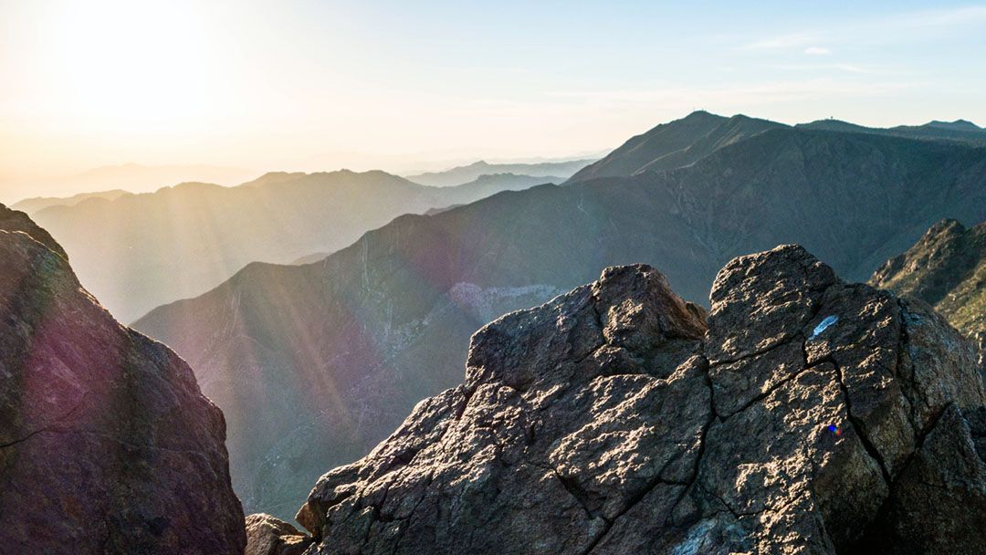
RELATED: Garnet Peak Trail – Catch a Sunrise on the Summit in the Laguna Mountains
Trailhead Information and Facilities
The trailhead, located just off the Pacific Crest Trail, offers easy access to this popular Laguna Mountain hiking trail. Parking is also available at the Penny Pines trailhead, ensuring convenient access to the PCT and Garnet Peak Trail. Please note that an Adventure Pass is required in most areas around Cleveland National Forest. Facilities are minimal at the trailheads, so remember to pack all your essentials!
About Garnet Peak Trail
The hike is a manageable 2.4 miles round-trip, an ideal hiking trail for moderate-level hikers and trail runners. The well-defined path leads you on a steady climb with an elevation gain of 613 feet, reaching a peak elevation of 5,880 feet. Garnet Peak is also a kid-friendly, dog-friendly trail, perfect for a family day out in the Laguna Mountains.
Hiking Garnet Peak Trail
Starting at the trailhead, follow the Pacific Crest Trail eastward until you hit the marked junction for Garnet Peak. Continue along the trail, noticing the gradual change in vegetation from chaparral to Jeffrey Pines as you ascend. At the peak, take a moment to absorb the 360-degree views before retracing your steps back to the trailhead. Allow approximately 1.5 hours for this Laguna Mountain hike, but you might want to allocate more time to enjoy the magnificent vistas!
What to Expect When Hiking Laguna Mountain Trails
The Garnet Peak trail, one of the noteworthy Laguna Mountain trails, is known for its well-maintained path with a few rocky patches – sturdy footwear is advised. It’s open year-round, but spring and fall offer milder temperatures and vibrant foliage. Remember your water bottle, sunscreen, and a hat for this sun-soaked hike in the Laguna Mountains. Keep an eye out for local wildlife, such as deer and hawks, adding an extra dose of nature to your hiking experience.
This is not just a hike – it’s a serene escape amidst the Laguna Mountains, boasting some of the most breathtaking vistas of San Diego’s backcountry. Whether you’re a seasoned hiker or a casual weekend adventurer, this hike offers an unforgettable day exploring the Laguna Mountains.
When to Go
- Fall
- Spring
- Summer
- Winter
What to Bring & Wear
- Adventure Pass is required in most areas around Cleveland National Forest
- At least one liter of water